


Frederick Precinct 16-001, Frederick County, Maryland
About
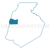
Outline

Summary
| Unique Area Identifier | 592359 |
| Name | Frederick Precinct 16-001 |
| County | Frederick County |
| State | Maryland |
| Area (square miles) | 22.95 |
| Land Area (square miles) | 22.87 |
| Water Area (square miles) | 0.08 |
| % of Land Area | 99.67 |
| % of Water Area | 0.33 |
| Latitude of the Internal Point | 39.50791890 |
| Longtitude of the Internal Point | -77.56080760 |
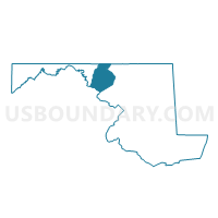
Maps

Graphs
Select a template below for downloading or customizing gragh for Frederick Precinct 16-001, Frederick County, Maryland


Neighbors
Neighoring Voting District (by Name) Neighboring Voting District on the Map
- Frederick Precinct 03-001, Frederick County, MD
- Frederick Precinct 03-002, Frederick County, MD
- Frederick Precinct 06-001, Frederick County, MD
- Frederick Precinct 20-001, Frederick County, MD
- Frederick Precinct 21-001, Frederick County, MD
- Washington Precinct 06-001, Washington County, MD
- Washington Precinct 16-001, Washington County, MD
Top 10 Neighboring County Subdivision (by Population) Neighboring County Subdivision on the Map
- District 3, Middletown, Frederick County, MD (10,025)
- District 21, Tuscarora, Frederick County, MD (9,961)
- District 6, Boonsboro, Washington County, MD (6,116)
- District 16, Jackson, Frederick County, MD (4,208)
- District 16, Beaver Creek, Washington County, MD (3,852)
- District 20, Lewistown, Frederick County, MD (3,115)
- District 6, Catoctin, Frederick County, MD (2,107)
Top 10 Neighboring Place (by Population) Neighboring Place on the Map
Top 10 Neighboring Unified School District (by Population) Neighboring Unified School District on the Map
Top 10 Neighboring State Legislative District Lower Chamber (by Population) Neighboring State Legislative District Lower Chamber on the Map
- State Legislative Subdistrict 3A, MD (93,508)
- State Legislative Subdistrict 4A, MD (81,354)
- State Legislative Subdistrict 2B, MD (44,013)
Top 10 Neighboring State Legislative District Upper Chamber (by Population) Neighboring State Legislative District Upper Chamber on the Map
- State Senate District 3, MD (147,548)
- State Senate District 2, MD (131,810)
- State Senate District 4, MD (125,297)
Top 10 Neighboring 111th Congressional District (by Population) Neighboring 111th Congressional District on the Map
Top 10 Neighboring Census Tract (by Population) Neighboring Census Tract on the Map
- Census Tract 114, Washington County, MD (5,701)
- Census Tract 113.02, Washington County, MD (3,909)
- Census Tract 7707, Frederick County, MD (3,608)
- Census Tract 7528.02, Frederick County, MD (3,550)
- Census Tract 7513.01, Frederick County, MD (3,418)
- Census Tract 7528.01, Frederick County, MD (2,214)